Drone Surveyors
Roof and building inspection
The main job: every slope, elevation, stack and gutter photographed close enough to make a decision on, without anything touching the building.
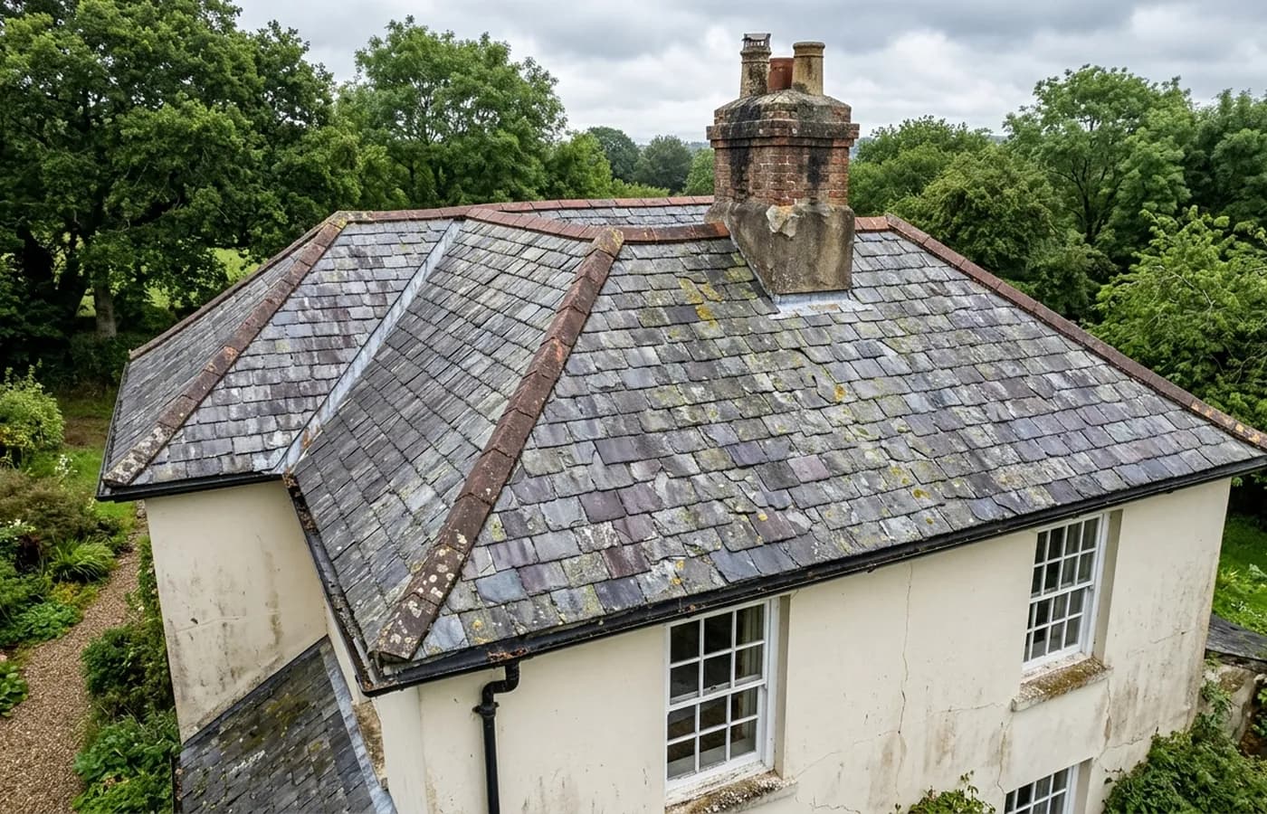
This is most of the work. A house, a church, a block of flats, a farm range or a commercial unit, photographed from the air until every roof slope and every elevation has been covered, then again in close detail wherever something has shown up.
The reason people commission it is almost always access. The alternative is a scaffold, a tower or a roofer on a ladder taking pictures on a phone, and all three are slower, dearer and less complete. The aircraft gets to the far side of a valley gutter or the back of a chimney stack in a couple of minutes and comes back with a frame you can zoom into.
What you are actually buying is the reading afterwards. A slipped slate is easy to spot. Knowing whether a hairline in the flaunching matters this winter or in five years is the part that comes from having worked on buildings rather than just photographed them.
What is included
- Every roof slope and every elevation covered systematically, not just the side that prompted the call
- Close detail frames of ridge, hip, valley, verge, abutment, flashing and stack
- Rainwater goods looked into rather than at: gutters, hoppers, outlets and parapet gutters
- Flat roof coverings photographed straight down, including outlets and upstands
- A written note against each observation saying what it is and whether it needs doing
- A plain list of anything that could not be seen on the day, and why
- Full resolution files, yours to forward to a roofer, an agent or an insurer
What a drone can see, and what it cannot
From the air you can see the whole covering at once, which nobody standing on the ground can. Slipped, cracked and delaminating slates, lifted or missing tiles, failed pointing and flaunching on stacks, lead that has crept or split, blocked and silted gutters, plant growth in valleys, standing water on flat roofs and daylight through boarding are all visible and all photographable at a distance that makes them readable.
What it cannot do is see through anything. Nothing under the covering, inside the roof space, behind the render or beneath standing water can be reported on, and a survey flown in November over a roof half covered in leaf litter tells you less than the same roof in March. Where the view is blocked, the report says so rather than leaving a gap that reads as approval.
It also is not a structural assessment. If a ridge line is visibly dipping, that goes in the report along with a recommendation to get somebody with a moisture meter and a torch into the loft. Knowing where the aerial job stops is part of the job.
Buildings this suits particularly well
Anything tall, anything steep, anything with a complicated roofscape, and anything where putting up an access platform costs more than the survey. Church towers, mill buildings, Victorian villas with three or four roof planes meeting in a lead valley, and terraces where the only way to the rear slope is through a neighbour's garden.
Occupied buildings do well out of it too. A block of flats can be surveyed in an afternoon without a single resident being asked to move a car or tolerate a scaffold, and a working farm carries on around it.
What the fee covers
A fixed price for the job as described, agreed before the visit, with travel from Exeter inside it. If what turns up on arrival is materially different from what was described, the price is re-agreed before anything is flown rather than adjusted afterwards.
If the weather stops the flight, the visit is rescheduled and nothing is charged for the wasted trip. That is the operator's risk to carry, not the client's.
On the day
How a roof and building runs
- Step 1
Scope on the phone
What the building is, what has prompted the call, and whether there is anything specific that has to be covered. Five minutes here saves an hour on site.
- Step 2
Site and airspace check
What sits next to the property, where the aircraft can be flown from, and whether airspace affects it. Done before the quote so the price does not move afterwards.
- Step 3
The overview run
Each elevation and each slope in turn from a working distance, so the report has context frames before it has close ones.
- Step 4
The detail run
Back in close on everything the overview turned up, plus the places faults usually hide whether or not they showed from further out.
- Step 5
Reading and writing
Every frame at full resolution at the desk, and a note against each observation. The report goes out within 48 hours of the flight.
Behind the work
Kit, cover and qualifications
Registered with the CAA
A registered operator with both an Operator ID and a Flyer ID. The Operator ID is the one that has to be displayed on the aircraft, and it is the number a client or an insurer asks for.
A2 Certificate of Competency
The A2 CofC is the theory and self-practical qualification that sits above the basic Flyer ID test. There is no GVC, which is stated here rather than left out, because it changes how some sites have to be planned.
Insured with Coverdrone
Commercial cover through Coverdrone, one of the specialist drone insurers. A copy of the certificate goes out on request before a booking, not after it.
DJI Mavic 4 Pro
The main survey aircraft. A 100 megapixel Hasselblad camera and 6K video, which is what lets a photograph of a ridge from twenty metres away still show an open mortar joint.
DJI Mavic 2 Enterprise Advanced
The thermal aircraft. A 640 by 512 radiometric thermal camera alongside the visual one, so a heat pattern can be read against the picture of the same elevation.
Construction background
The surveying came after years of contracting, so the report is written by somebody who has stood on the scaffold as well as flown over it, and who knows which faults matter and which are cosmetic.
Written report within 48 hours
A process commitment, not a sales promise. The flight is the short part of the job; the report is where the time goes, and it lands within two days of the visit.
No scaffolding, no ladders
Nothing leans on the building and nobody goes up it. That removes the access cost, the permit paperwork and the working-at-height risk from the survey itself.
Roof and building
Roof and building inspection questions
- How long does the flight take?
- Twenty minutes to an hour in the air for most buildings, plus setting up and packing down. A farm range or a block of flats takes longer than a semi.
- Do I need to be there?
- Not usually, as long as there is access to the ground the aircraft will fly from and somebody knows the visit is happening. For an occupied property it helps if the occupier has been told, so nobody rings the police about a drone over the garden.
- Will it work on a terraced street?
- Often, but it is exactly the case worth discussing first. Terraces put other people's property and other people's gardens close to the flight, and that shapes where the aircraft can be flown from and how close it can get. It gets checked before the quote.
- Can you photograph the inside of the loft?
- No. This is an external survey. If the loft matters, the report will say that somebody needs to get into it, and a roofer or a building surveyor is the right person for that.
Where
Roof and building inspection across the South West
Also on this site
See the credentials
Talk to a surveyor with Drone Surveyors
Tell us the address and what you need looking at. Sam Hembury will come back with a fixed price and the next available slot.